

1) 70 Washington Square and York St, before the construction of the BQE highway, 1926 (New York Public Library). 2) A ground view of the BQE expressway, which illustrates its over looming presence, 2009 (Clare Delaney).
Location of the Brooklyn Heights Promenade: The promenade or esplanade runs along Columbia Heights Street from Middiagh Street to Montague St.
Transit: Take the A or C train to High Street. Turn right on Cadman Plaza West, turn left onto Middagh Street, which will leave you to the Promenade.
The Brooklyn-Queens Expressway is part of Interstate 278 and runs from southern Brooklyn in Red Hook, where it connects with the Gowanus Expressway to Grand Central Parkway in Queens. In 1940 Robert Moses, the supposed “master builder,” proposed an expressway linking Brooklyn and Queens to lessen traffic. Moses valued the erection of highways over the advancement of public transportation, and while he oversaw the construction of every major high way in New York (except for the FDR Drive) over many decades, no new extensions or lines were added to mass transit although a few were proposed. In 1944 Congress allocated twenty-five percent of federal highway funds for the construction of new roads in cities, enabling the construction of the BQE (Short). Beginning construction in 1951, the BQE now runs close to the industrial waterfront from its southernmost point until it intersects with Kent Avenue in Williamsburg (National Research Council). The construction of the roadway literally razed large physical areas of neighborhoods (in some cases totally demolishing entire neighborhoods) and furthermore served to divide other neighborhoods, destroying their character and displacing residents (Short).
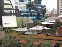
Only Brooklyn Heights was saved from the fate of destruction or division served to most neighborhoods by Moses’ Expressway. In the original plan, the Expressway ran along Hicks Street, the trajectory it follows southward into Red Hook. The Brooklyn Heights Association, founded in 1910, lobbied Moses and the City to move the highway west at Atlantic Avenue, nearer to the East River thereby preventing the bisection of their community. The collective organization of many neighborhood residents, in coalition with the Association, persuaded Moses to move construction of the BQE westward and created a promenade, overlooking the river, with majestic views of lower Manhattan. The promenade runs along Columbia Heights Street from Middiagh Street to Montague St, almost the entire length of Brooklyn Heights. The power of the Brooklyn Heights Association came from residents’ affluence and the historical influence of many residents of the neighborhood, which has been described as “New York’s first suburb.” The neighborhood contains blocks filled with charming and historic row houses and mansions built in a variety of styles (Lancaster and Gillon). Brooklyn Heights was saved from ruination because of the political and economic power of their active and long organized community association and the picturesque quality of the neighborhood these qualities are all markers of the neighborhoods white privilege. Unfortunately Red Hook, Fort Greene, Williamsburg and Greenpoint did not have these recourses available.
In these less affluent and more racially and ethnically diverse neighborhoods, despite protest large sections were demolished and replaced by the loud, ugly, pollution-producing Expressway. It is especially glaring in the case of Red Hook where the Promenade could somewhat easily have been continued, or replicated, along Van Brunt Street, but instead at Atlantic Avenue it was moved back to its originally intended route along Hicks Street causing massive destruction and dislocation. Putting an elevated or open-cut expressway through a neighborhood ensures that the surrounding property is unlikely to ever accrue exchange value. The lands’ use value is also severely limited by the Expressway as it uproots many residents and creates an unnatural border. The border changes the existing culture of the neighborhood and “exerts [its own] active influence…[which is] the blight-proneness of zones along the [borders]” (Jacobs). Highways, and other unwanted land uses, are continuously placed in low-income, predominantly minority neighborhoods causing the destruction of these spaces/communities and leaving the population with the documented additional health risks of pollution (Lee). Furthermore it signals the devaluation of the community as a place to be driven though to get somewhere else.
- Clare Delaney and Upahar Rana
Sources
Jacobs, Jane. The Death and Life of Great American Cities. New York: Random House Inc., 1989.
Lancaster, Clay and Edmund Vincent Gillon. Old Brooklyn Heights New York’s First Suburb. Toronto: Dover Publications, Inc., 1979.
Lee, Robert E. “The Size of Suspended Patriculate Matter in Air.” Science Vol. 178 No. 4061 (1972): 567-575.
The National Research Council Committee on Urban Waterfront Lands. Urban Waterfront Lands. Washington: Office of Publication National Academy of Sciences, 1980.
Short, John R. Alabaster Cities: Urban U.S. Since 1950. New York: Syracuse University Press, 2006.
Brooklyn-Queens Expressway looks a great place. I like to see this place while driving. deals for cheap park and fly
ReplyDelete